| Our Plans for the Route 50 Corridor 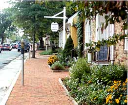 The Route 50 Corridor Coalition approach has focused on the needs of the local community and been an open, participative process seeking to meet the individual needs of each community and preserve the quality of the region The Route 50 Corridor Coalition approach has focused on the needs of the local community and been an open, participative process seeking to meet the individual needs of each community and preserve the quality of the region
Route 50 in Middleburgs commercial area The Community's Vision The Route 50 Corridor Coalitions goal is to participate in community initiatives to preserve the areas heritage and to further the vision of the citizens. We must never forget that Virginia roads belong to the people and not to a government bureaucracy... Virginia has a unique opportunity for leadership in transportation by applying a concept called traffic calming. James E. Rich,
Virginia Commonwealth Transportation Board The Community's Preliminary Plan The community's preliminary plan was developed by citizens during workshops. 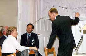 Thus, it represents what the people want, not only for their community, but for the road, street, and sidewalk in front of their homes or businesses, and for the towns they frequent. Thus, it represents what the people want, not only for their community, but for the road, street, and sidewalk in front of their homes or businesses, and for the towns they frequent. Citizens discuss the Traffic Calming Plan with Ian Lockwood at the Aldie Workshop Route 50 Rural Traffic Calming Pilot Project The communities along and near the Route 50 Corridor are very concerned about incremental degradation and its long term effects, and has taken immediate action through initiating a Rural Traffic Calming Pilot Project. This should have been done a long time ago. Participant, May 19 Workshop in Middleburg Where To Go From Here Interested parties from all over the country have contacted the Coalition to learn about the Plan and are waiting to see the outcome. This section addressess the next steps in making the plan a reality. Although the region recovered from the Civil War, it could never recover from the blacktop and concrete revolution that threatens it today. To pave over the northern Piedmont would pave over much of America's past permanently. Foreward to Hallowed Ground James McPherson, Edwards Professor of American History, Princeton Univerisity The Workshops This section outlines the plan developed by the citizens and documented in the 1996 report published by the Coalition. The report includes geographical and historical background, the communitys vision, an introduction to traffic calming, and describes the communitys plan for traffic calming Route 50. More than 300 people directly contributed to the plan through participation in public workshops and an open house. Because of the way the plan was prepared in public and by the public it enjoys a high level of community support. It is referred to as a preliminary plan because citizens will have future opportunities to make adjustments as it is prepared in greater detail and, ultimately, as the project is engineered for construction The 1996 report details the traffic calming features proposed for Aldie, Middleburg, and Upperville. The supplement to the report provides reproductions of the actual maps on which the citizens drew their traffic calming ideas and wrote their comments. In general the plan adheres to four principles that were developed during the workshops: - Travelers will be informed that they are arriving and leaving distinctive areas through the use of entrance features. The areas include The Mosby Heritage Area, Aldie, Middleburg, Upperville, and Paris.
- The feeling of the road between the towns will be different from the rest of Route 50, and the feeling of the main streets in the villages will be different from that of the road. The entrance features therefore will indicate a meaningful transition.
- The maximum posted speed limits between the villages will be 50 mph and within the villages, 25 mph. Transition areas will be posted at 35 mph.
- Traffic calming measures will be used in the villages, not to impede traffic, but to help self-enforce the desired speeds and to accommodate pedestrians, cyclists, and other non-motorized users.
Outside the Villages The design of the road outside the villages calls for: - A paved surface that will remain at its current width edged with grass shoulders constructed according to the National Park Services guidelines for building stabilized grass shoulders.
- Shrubbery and trees planted and allowed to grow as close to the edge of the road as possible.
- Guardrails, where needed, made of natural material, such as steel-reinforced wood or concrete clad with stone similar to those used on the George Washington Parkway (following the U.S. Department of Transportation, Federal Highway Administrations Summary Report on Aesthetic Bridge Rails and Guardrails, No. FHWA-SA-91-051).
- All roadside stone walls to be preserved or restored if in disrepair.
- Planted median strips or an area of white cobblestone to replace the areas marked with painted lines at intersections where there are turn lanes.
- Historic markers, designed with community input, explaining the rich history of the area, and
- Pull-off areas to permit emergency vehicles to pass and to enable visitors to stop and enjoy the scenery.
Within the Villages To help alert drivers that they are arriving at each village, additional precautions are taken prior to the entrance features. Where the speed limit has been reduced to 35 mph, a series of strips of cobblestone or paving stone are built across the road at increasingly closer spacing to get drivers attention. Trees or other plantings placed near both ends of the strips make the strips more conspicuous. At the entrance features, the speed limit changes to 25 mph. The plan defines the main street in each village as Route 50 between the entrance features. The street design changes so that drivers will readily perceive it as different from the rest of the road. Where there are no curbs, the white lines on the sides of the main streets are replaced with rows of white paving stones embedded at street level to form a border between the asphalt and the grass shoulders. Where there are curbs, they are the mountable type so that vehicles can pull over in case of a breakdown or to allow the passage of emergency vehicles. Typical measures within the villages include raised intersections and raised pedestrian crosswalks, tree-planted medians, small traffic circles, various paving materials to indicate parking, walking, and driving areas, strategically placed greenery along the streets, and safer pedestrian walkways, which are badly needed. Traffic calming features for each village: Return to top of page |